
I love OpenFreeMap it is a quick, easy, and free way to add beautiful maps to your Open Source projects. With the latest release of MapLibre-GL I wanted to see if there was an easy way to use both to make an interactive globe with clustered markers. Spoiler alert: yes! Basic Globe Here's a basic example which I've trimmed down from this example. When you load the below code, you'll get a…
Continue reading →
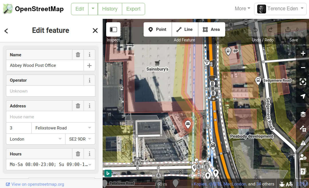
Today was quite the accidental milestone! I've edited OpenStreetMap over a thousand times! For those who don't know, OSM (OpenStreetMap) is like the Wikipedia of maps. Anyone can go in and edit the map. This isn't a corporate-controlled space where your local knowledge is irrelevant compared to the desire for profit. You can literally go and correct any mistakes that you find, add recently…
Continue reading →

I used to like the original FourSquare. The "mayor" stuff was a bit silly, and my friends never left that many reviews, but I loved being able to signal to my friends "I am at this cool museum" or "We're at this pub if you want to meet" or "Spending the day at the park". So, is there a way to recreate that early Web 2.0 experience with open data and ActivityPub? Let's find out! This quest is…
Continue reading →
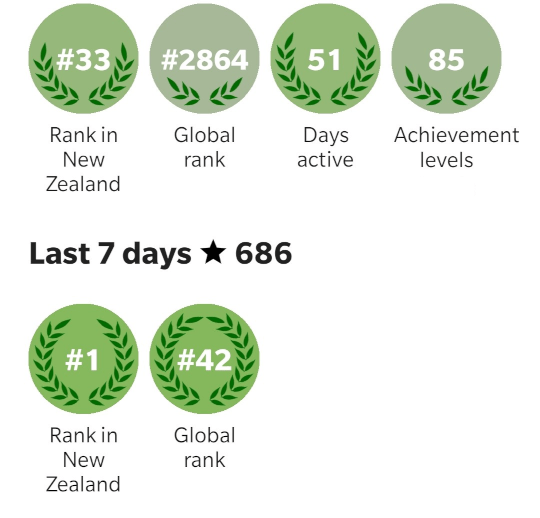
I hate leaderboards. I think competition tends to corrupt the incentives people have to contribute to a goal. Yet, at the same time, I was delighted to see that I was the top mapper in the whole of Aotearoa New Zealand. For one specific week in December. They say golf is a good walk spoiled. StreetComplete is a good walk enhanced with sidequests. As you wander around, it asks you little…
Continue reading →

If you've seen that episode of The West Wing, you'll remember this scene: I'm not a paying member of the OCSE, but I fully support their aims. Because messing around with maps is fun. So, can I build a web-first maps which is South-up, Pacific-centred, and Peters-projected? Here's what I managed to do using OpenLayers - an Open Source web maps library which is pretty hackable. Get started …
Continue reading →

English is a funny old language. That my mother tongue doesn't bother with internal consistency doesn't bother me much - except when it comes to Text-To-Speech. Using Google Maps to provide route guidance in the UK is a challenging affair. Driving through Reading, the computerised voice continually mispronounced is as "Reading". Err... that is to say, it should have said "ˈrɛdɪŋ" instead it sai…
Continue reading →